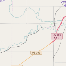
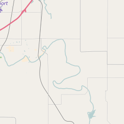
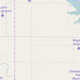
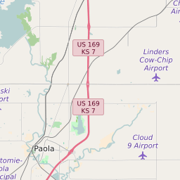
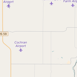
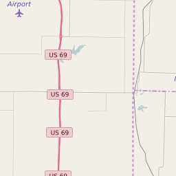
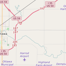
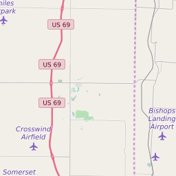
Map of ZIP Code 66071 Precinct Level Results for the 2020 Presidential Election
D 80-100% |
D 70-80% |
D 60-70% |
D 45-60% |
R 45-60% |
R 60-70% |
R 70-80% |
R 80-100% |


List of ZIP Code 66071 Precinct Level Results for the 2020 Presidential Election | ||||||||
|---|---|---|---|---|---|---|---|---|
| Map Index | Precinct | City/Town | ZIP Code | Joe Biden Democrat | Donald Trump Republican | Jo Jorgensen Libertarian | ||
| East Middle Creek Township C2 Voting District | 66071 | 37 (23.57%) | 117 (74.52%) | 3 (1.91%) | ||||
| East Valley Township Voting District | 66071 | 70 (26.82%) | 187 (71.65%) | 4 (1.53%) | ||||
| Miami Township Voting District | 66053 | 90 (27.78%) | 228 (70.37%) | 6 (1.85%) | ||||
| North Paola Township Part 1 Voting District | 66071 | 4 (36.36%) | 7 (63.64%) | 0 (0%) | ||||
| North Paola Township Part 2 Voting District | 66071 | 24 (25.53%) | 70 (74.47%) | 0 (0%) | ||||
| North Paola Township Voting District | 66071 | 79 (27.92%) | 198 (69.96%) | 6 (2.12%) | ||||
| Osage Township Voting District | Fontana | 66040 | 95 (28.36%) | 234 (69.85%) | 6 (1.79%) | |||
| Osawatomie Township Voting District | Osawatomie | 66042 | 111 (26.37%) | 301 (71.5%) | 9 (2.14%) | |||
| Osawatomie Ward 1 H5 | Osawatomie | 66071 | 108 (35.53%) | 185 (60.86%) | 11 (3.62%) | |||
| Paola Ward 1 | Paola | 66071 | 234 (34.41%) | 437 (64.26%) | 9 (1.32%) | |||
| Paola Ward 2 | Paola | 66071 | 172 (29.4%) | 399 (68.21%) | 14 (2.39%) | |||
| Paola Ward 3 | Paola | 66071 | 212 (35.51%) | 372 (62.31%) | 13 (2.18%) | |||
| Paola Ward 4 | Paola | 66071 | 309 (36.87%) | 508 (60.62%) | 21 (2.51%) | |||
| Richland Township Voting District | 66083 | 312 (24.84%) | 918 (73.09%) | 26 (2.07%) | ||||
| South Marysville Township C2 Voting District | Hillsdale | 66083 | 223 (26.84%) | 591 (71.12%) | 17 (2.05%) | |||
| South Marysville Township C3 Voting District | 66071 | 6 (37.5%) | 10 (62.5%) | 0 (0%) | ||||
| South Paola Township Part 2 Voting District | 66071 | 28 (22.76%) | 93 (75.61%) | 2 (1.63%) | ||||
| South Paola Township Voting District | Paola | 66071 | 42 (24.56%) | 123 (71.93%) | 6 (3.51%) | |||
| Stanton Township Voting District | Osawatomie | 66079 | 132 (26.83%) | 352 (71.54%) | 8 (1.63%) | |||
| Ten Mile Township Voting District | Somerset | 66053 | 282 (28.95%) | 674 (69.2%) | 18 (1.85%) | |||
| West Middle Creek Township Voting District | Somerset | 66053 | 133 (29.23%) | 320 (70.33%) | 2 (0.44%) | |||
| West Valley Township Exclave Voting District | Osawatomie | 66064 | 75 (30%) | 172 (68.8%) | 3 (1.2%) | |||
| West Valley Township H5 | 66064 | 43 (27.39%) | 109 (69.43%) | 5 (3.18%) | ||||
| West Valley Township H6 | 66064 | 49 (35.51%) | 87 (63.04%) | 2 (1.45%) | ||||