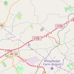
Map of ZIP Code 40014 Precinct Level Results for the 2020 Presidential Election
D 80-100% |
D 70-80% |
D 60-70% |
D 45-60% |
R 45-60% |
R 60-70% |
R 70-80% |
R 80-100% |

List of ZIP Code 40014 Precinct Level Results for the 2020 Presidential Election | ||||||||
|---|---|---|---|---|---|---|---|---|
| Map Index | Precinct | City/Town | ZIP Code | Joe Biden Democrat | Donald Trump Republican | Jo Jorgensen Libertarian | ||
| BRIAR HILL | Pewee Valley | 40014 | 622 (39.47%) | 930 (59.01%) | 24 (1.52%) | |||
| CARRIAGE HILL | 40014 | 79 (34.5%) | 145 (63.32%) | 5 (2.18%) | ||||
| CLORE | Crestwood | 40014 | 224 (36.78%) | 378 (62.07%) | 7 (1.15%) | |||
| CRESTWOOD | Crestwood | 40014 | 329 (39.98%) | 480 (58.32%) | 14 (1.7%) | |||
| EAST BALLARDSVILLE | La Grange | 40031 | 349 (27.12%) | 925 (71.87%) | 13 (1.01%) | |||
| EAST BROWNSBORO | 40014 | 261 (40.47%) | 376 (58.29%) | 8 (1.24%) | ||||
| EAST WORTH | 40014 | 378 (30.76%) | 833 (67.78%) | 18 (1.46%) | ||||
| NORTH 22 | Orchard Grass Hills | 40241 | 512 (45.63%) | 591 (52.67%) | 19 (1.69%) | |||
| NORTH CRESTWOOD | Crestwood | 40014 | 710 (43.4%) | 897 (54.83%) | 29 (1.77%) | |||
| NORTH PEWEE VALLEY | Pewee Valley | 40014 | 420 (40.35%) | 610 (58.6%) | 11 (1.06%) | |||
| NORTHWOOD | 40014 | 80 (33.61%) | 152 (63.87%) | 6 (2.52%) | ||||
| SOUTH CRESTWOOD | 40014 | 168 (31.58%) | 360 (67.67%) | 4 (0.75%) | ||||
| SOUTH LAGRANGE | La Grange | 40014 | 449 (35.19%) | 806 (63.17%) | 21 (1.65%) | |||
| WEST BALLARDSVILLE | 40014 | 190 (29.19%) | 450 (69.12%) | 11 (1.69%) | ||||
| WEST BROWNSBORO | Crestwood | 40014 | 574 (39.97%) | 845 (58.84%) | 17 (1.18%) | |||
| WEST BUCKNER | Buckner | 40031 | 294 (38.28%) | 460 (59.9%) | 14 (1.82%) | |||
| WEST WORTH | 40014 | 551 (36.71%) | 922 (61.43%) | 28 (1.87%) | ||||
| WORTH | 40014 | 339 (38.26%) | 534 (60.27%) | 13 (1.47%) | ||||