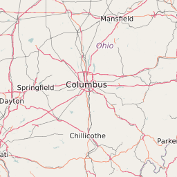
Population Change for Counties in Ohio - 2010 to 2022
of the 88 Counties in Ohio the fastest growing County is Delaware County with 22.91% growth. The County lowest growth is Harrison County with -8.71% growth.
Ohio Population Change Map
< -15% | -15% to -5% | -5% to 0% | 0% to 5% | 5% to 15% | > 15% |
List of Counties in Ohio With Population Percentage Change | |||||
|---|---|---|---|---|---|
| Map Key | Name | Population Change | Population | ||
| Adams County | -3.76% | 28,524 | |||
| Allen County | -3.88% | 106,079 | |||
| Ashland County | -1.3% | 53,203 | |||
| Ashtabula County | -3.87% | 101,262 | |||
| Athens County | -3.59% | 64,592 | |||
| Auglaize County | 1.03% | 45,934 | |||
| Belmont County | -5.54% | 70,182 | |||
| Brown County | -2.61% | 44,666 | |||
| Butler County | 6.04% | 368,029 | |||
| Carroll County | -7.33% | 28,828 | |||
| Champaign County | -3.45% | 39,982 | |||
| Clark County | -1.69% | 138,278 | |||
| Clermont County | 5.69% | 197,543 | |||
| Clinton County | -0.05% | 42,161 | |||
| Columbiana County | -5.53% | 107,598 | |||
| Coshocton County | -0.78% | 36,880 | |||
| Crawford County | -4.02% | 43,623 | |||
| Cuyahoga County | -1.2% | 1,278,024 | |||
| Darke County | -2.04% | 52,776 | |||
| Defiance County | -1.92% | 38,975 | |||
| Delaware County | 22.91% | 174,454 | |||
| Erie County | -1.89% | 76,952 | |||
| Fairfield County | 8.73% | 146,138 | |||
| Fayette County | -0.27% | 28,931 | |||
| Franklin County | 13.79% | 1,167,484 | |||
| Fulton County | 0.04% | 42,635 | |||
| Gallia County | -5.54% | 30,877 | |||
| Geauga County | 2.15% | 93,485 | |||
| Greene County | 3.96% | 161,936 | |||
| Guernsey County | -4.11% | 40,056 | |||
| Hamilton County | 3.52% | 801,350 | |||
| Hancock County | 0.18% | 75,043 | |||
| Hardin County | -4.25% | 31,986 | |||
| Harrison County | -8.71% | 15,818 | |||
| Henry County | -1.96% | 28,246 | |||
| Highland County | -0.62% | 43,454 | |||
| Hocking County | -4.53% | 29,372 | |||
| Holmes County | 4.38% | 42,501 | |||
| Huron County | -1.78% | 59,628 | |||
| Jackson County | -1.72% | 33,134 | |||
| Jefferson County | -6.4% | 69,343 | |||
| Knox County | 2.95% | 60,791 | |||
| Lake County | 1.11% | 229,873 | |||
| Lawrence County | -6.74% | 62,441 | |||
| Licking County | 7.22% | 166,135 | |||
| Logan County | 0.64% | 45,816 | |||
| Lorain County | 3.85% | 301,108 | |||
| Lucas County | -2.38% | 441,198 | |||
| Madison County | 0.9% | 43,213 | |||
| Mahoning County | -4.27% | 238,352 | |||
| Marion County | -1.72% | 66,514 | |||
| Medina County | 5.88% | 172,334 | |||
| Meigs County | -6.56% | 23,664 | |||
| Mercer County | 4.2% | 40,866 | |||
| Miami County | 6.11% | 102,657 | |||
| Monroe County | -8.58% | 14,679 | |||
| Montgomery County | 0.4% | 535,626 | |||
| Morgan County | -8.32% | 15,042 | |||
| Morrow County | 0.35% | 34,895 | |||
| Muskingum County | 0.39% | 85,996 | |||
| Noble County | -3.62% | 14,643 | |||
| Ottawa County | -2.57% | 41,445 | |||
| Paulding County | -4.12% | 19,522 | |||
| Perry County | -1.8% | 36,086 | |||
| Pickaway County | 5.1% | 55,795 | |||
| Pike County | -5.65% | 28,652 | |||
| Portage County | 0.23% | 161,178 | |||
| Preble County | -3.01% | 42,240 | |||
| Putnam County | -0.14% | 34,445 | |||
| Richland County | 0.37% | 124,286 | |||
| Ross County | -1.24% | 77,741 | |||
| Sandusky County | -3.36% | 60,842 | |||
| Scioto County | -6.91% | 79,122 | |||
| Seneca County | -2.95% | 56,630 | |||
| Shelby County | -2.41% | 49,359 | |||
| Stark County | -0.2% | 375,593 | |||
| Summit County | -0.25% | 541,788 | |||
| Trumbull County | -3.96% | 209,942 | |||
| Tuscarawas County | 0.74% | 92,532 | |||
| Union County | 20.05% | 52,153 | |||
| Van Wert County | 0.65% | 28,808 | |||
| Vinton County | -4.73% | 13,397 | |||
| Warren County | 13.94% | 213,146 | |||
| Washington County | -3.25% | 61,751 | |||
| Wayne County | 2.07% | 114,644 | |||
| Williams County | -1.43% | 37,779 | |||
| Wood County | 5.39% | 126,254 | |||
| Wyandot County | -3.16% | 22,626 | |||