ZipDataMaps
Blog
About
Data and Maps
US ZIP Codes
ZIP Code Tools
Canada Postal Codes
Area Codes
Politics
POI Data
Regional Market Areas
Neighborhoods
Economics
Counties
Places
Schools
Home
Georgia Regional Market Areas
Columbus-Auburn-LaGrange Area
Columbus-Auburn-LaGrange Area, Georgia - Regional Market Area
Map
Profile
Related
Columbus-Auburn-LaGrange Area Boundary Map
+
−
Leaflet
|
©Zipdatamaps
©OpenStreetMap Contributors
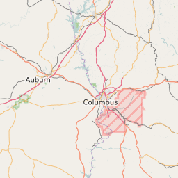
Columbus-Auburn-LaGrange Area Profile
Region Name
Columbus-Auburn-LaGrange Area
Population (2021)
707874
Population Growth Rate (2017-2021)
2.30%
Total Counties
19
Columbus-Auburn-LaGrange Area Counties
Troup County
Sumter County
Marion County
Muscogee County
Harris County
Barbour County
Chattahoochee County
Webster County
Randolph County
Stewart County
Meriwether County
Heard County
Russell County
Quitman County
Lee County
Talbot County
Chambers County
Schley County
Clay County
Related Maps and Data:
Georgia Airports
Georgia Area Codes
Georgia Colleges and Universities
Georgia Congressional Districts Map
Georgia Metropolitan/Micropolitan Statistical Areas
Georgia Military Bases
Georgia Power Plants
Georgia Regional Market Areas
Georgia School Districts
Georgia State House of Representatives Map
Georgia State Senate Map
Georgia ZIP Code List
Georgia ZIP Code Map
Majority Race/Ethnicity for Counties in Georgia
Partisan Voting Index for Counties in Georgia
Poorest ZIP Codes in Georgia
Population Change for Counties in Georgia
Public School Majority Race/Ethnicity for Counties in Georgia
SNAP/Food Stamp Participation for Counties in Georgia
Unemployment Rate Heat Map for Cities and Counties in Georgia
Unemployment Rate for Counties in Georgia
Wealthiest ZIP Codes in Georgia
About
Contact
Terms
Privacy
ZIP Code Blog
Twitter
Facebook
E-mail
2025 zipdatamaps.com